


WinGPS™ Marine

WinGPS™ Marine का विवरण
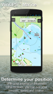
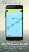
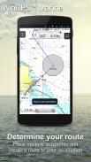
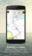
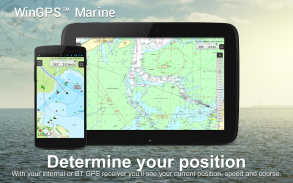
WinGPS मरीन आपको सुरक्षित यात्रा के लिए आधुनिक, सीखने में आसान नेविगेशनल उपकरण प्रदान करता है। अपना मार्ग प्लॉट करने के लिए चार्ट पर देर तक दबाएँ। जहाज पर लगा जीपीएस आपकी सटीक लोकेशन दिखाएगा। अपने डिवाइस पर चार्ट डाउनलोड करें और सबसे अद्यतित चार्ट के साथ ऑफ़लाइन नौकायन करें। अपने AIS को वाईफ़ाई के माध्यम से कनेक्ट करें और संभावित टकरावों को रोकें।
समुद्र, ज्वार और अंतर्देशीय जल में नौकायन और मोटर नौकाओं, स्लोप और डोंगी पर नेविगेशन के लिए स्टेंटेक द्वारा विकसित किया गया। नाव किराए पर लेते या किराये पर लेते समय आदर्श।
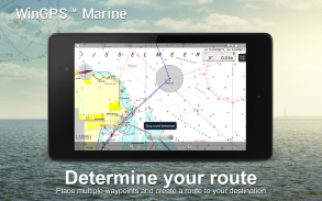
• पुल, ताले और जलमार्ग की जानकारी के साथ अंतर्देशीय चार्ट पश्चिमी यूरोप और डोनाउ के लिए जलमार्गों के लिए समर्थन। इसके साथ आप किसी भी बाधा का संकेत देते हुए, अपने मार्गों को शीघ्रता से प्लॉट और समायोजित कर सकते हैं। आपकी यात्रा के दौरान जलमार्गों के नाम और दूरियाँ दिखाई जाएंगी।
• स्मार्ट लेबलिंग एक इष्टतम चार्ट छवि के लिए ओवरलैपिंग टेक्स्ट लेबल (जलमार्ग के साथ भी) को रोकती है। कोर्स अप रोटेटिंग चार्ट पर ब्रिज और लॉक डेटा हमेशा पढ़ने योग्य होगा।
प्रकाश डाला गया
• स्टेंटेक, इमरे, एनओएए और डेलियस क्लासिंग के अप-टू-डेट चार्ट पर नेविगेट करना।
• चार्ट भंडारण के लिए एसडी-कार्ड समर्थन।
• ट्रैक, चार्ट, रूट और वेपॉइंट प्रबंधित करें।
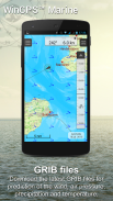
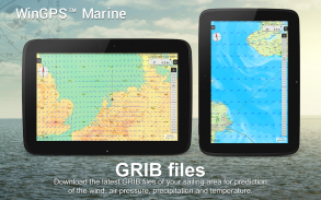
• NOAA वर्ल्ड GRIB-फ़ाइलें: हवा, वायु दबाव, वर्षा और तापमान।
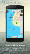
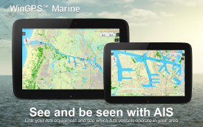
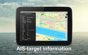
• वायरलेस वाईफ़ाई या ब्लूटूथ कनेक्शन के माध्यम से एआईएस और जीपीएस कनेक्ट करें।
• एआईएस जहाजों के स्पीड वैक्टर के साथ टकराव को रोकें।
• मैन-ओवरबोर्ड बटन खोए हुए क्रू-सदस्यों को पुनः प्राप्त करने में मदद करता है।
• चार्ट केन्द्रित जीपीएस स्थिति के नीचे चलता रहता है। नॉर्थअप, कोर्सअप (समुद्री) या हेडअप (प्लस)।
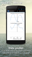
• विस्तृत मौसम पूर्वानुमान के साथ हार्मोनीमॉडल केएनएमआई (प्लस, केवल नीदरलैंड)
• खुले समुद्र में एनओएए लहर की भविष्यवाणी (प्लस, दुनिया भर में)
जब WinGPS मरीन पहली बार स्थापित किया जाएगा, तो यह सीमित कार्यों वाला WinGPS मरीन लाइट होगा। जीपीएस समर्थन के साथ चार्ट व्यूअर के रूप में आदर्श।
ऐप में खरीदारी
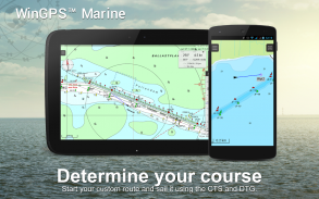
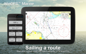
WinGPS मरीन को खरीदने के बाद, आप अपने व्यक्तिगत नेविगेशन सिस्टम की पूर्ण क्षमताओं को अनलॉक कर देंगे। अब आप रूट प्लॉट करने, जीआरआईबी फ़ाइलें डाउनलोड करने, पिछले ट्रैक सहेजने और एआईएस और जीपीएस कनेक्ट करने में सक्षम हैं। अनुमानित हवा, बारिश, वायु दबाव और एआईएस लक्ष्यों को देखने के लिए आसान समय सारणी का उपयोग करें।
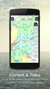
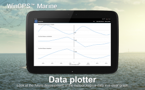
WinGPS मरीन प्लस अपग्रेड के साथ, आप अपने बोर्ड पीसी, मल्टीप्लेक्सर या एआईएस ट्रांसपोंडर से वायरलेस कनेक्शन के माध्यम से अतिरिक्त बोर्ड उपकरणों को कनेक्ट करने में सक्षम होंगे। आप अपने डेटा प्लॉटर में वर्तमान और ज्वारीय जानकारी प्रदर्शित कर सकते हैं या चार्ट पर देख सकते हैं। इसके अलावा, उन्नत केएनएमआई का हार्मोनी मौसम मॉडल दुनिया भर में एनओएए तरंगों के साथ-साथ समर्थित है।
KUSTFIJN गेटिजमॉडल रिजक्सवाटरस्टाट ने दो दिवसीय हवा के साथ वाडेनजी, इज्सेलमीर, मार्करमीर, रैंडमेरेन और ज़ीलैंड पर धाराओं, ज्वार और जल स्तर की भविष्यवाणियों पर निर्भर किया। लाल गहराई रेखाएं हवा के कारण गहराई, ज्वार और विचलन के आधार पर सुरक्षित जलमार्गों को सीमित करती हैं।
चार्ट कवरेज और चार्ट स्थापित करना
जब आप WinGPS मरीन शुरू करते हैं तो आपको स्वचालित रूप से ESRI का (ऑनलाइन) स्थलाकृतिक डिफ़ॉल्ट चार्ट दिखाई देगा। आप यूएस के एनओएए चार्ट भी चालू कर सकते हैं और चार्ट प्रबंधक के माध्यम से निःशुल्क विश्व चार्ट डाउनलोड कर सकते हैं
सुरक्षित नेविगेशन के लिए, आप www.stentec.com पर डिजिटल चार्ट खरीद सकते हैं। ऐप में या Google Play™ के माध्यम से चार्ट खरीदना भी संभव है। आपके चार्ट 3 अलग-अलग डिवाइस पर इंस्टॉल किए जा सकते हैं। उदाहरण के लिए, आपके एंड्रॉइड टैबलेट, फोन और विंडोज लैपटॉप या कंप्यूटर पर।
मरीन ऐप में अपने स्टेंटेक खाते से लॉग इन करें और चार्ट मैनेजर में अपने खरीदे गए DKW2 चार्ट डाउनलोड या अपडेट करें।
उदाहरण के लिए, साप्ताहिक BaZ अपडेट के साथ लोकप्रिय DKW1800 श्रृंखला और द्विसाप्ताहिक अपडेट के साथ NL चार्ट। हमारी ऑनलाइन दुकान अप-टू-डेट समुद्री चार्ट और डोनौ सहित पश्चिमी यूरोप के सभी अंतर्देशीय चार्ट प्रदान करती है।
अधिक जानकारी:
www.wingpsmarine.com
गोपनीयता नीति:
www.stentec.com/en/en/privacy-statement
उपयोगकर्ता इनपुट
ऐप में सुधार के लिए हम आपके अनुभव और सुझावों में बहुत रुचि रखते हैं। कृपया helpdesk@stentec.com पर एक ई-मेल भेजें।
WinGPS™ Marine - Version 4.75
(31-03-2025)
WinGPS™ Marine - एपीके जानकारी
एपीके संस्करण: 4.75पैकेज: com.stentec.wingps_marine_liteLatest Version of WinGPS™ Marine
अन्य संस्करण


Apps in the same category


